Drones Camera Resolution: Three Metrics You Should Know About
Pixel Resolution
The **pixel resolution** refers to the total number of pixels in an image, usually expressed as width x height (e.g., 1920 x 1080) or as the total number of pixels (e.g., 2.1 MP). This metric tells us how large the image is but doesn’t directly indicate how much detail can be seen.| Elios 1 Pixel Resolution | ||
| FHD video | 1920 x 1080 | 2.1 MP |
| Elios 2 Pixel Resolutions | ||
| FHD video | 1920 x 1080 | 2.1 MP |
| 4K video | 3840 x 2160 | 8.3 MP |
| Photo | 4’000 x 3’000 | 12 MP |
Â
While pixel resolution gives you an idea of image size, it doesn't tell you how much detail you can see. That’s where other metrics like Ground Sampling Distance (GSD) and Spatial Resolution come into play.
| Metric | Application |
| Pixel resolution | Data sharing, display, zooming |
| Ground sampling distance (GSD, mm/px) | Measurements, photogrammetry |
| Spatial resolution (lp/mm) | Object detection, detail characterization |
Â
Ground Sampling Distance (GSD)
The **ground sampling distance (GSD)** measures how much real-world space one pixel represents. For example, a GSD of 1 mm/px means each pixel covers 1 mm of the object. A smaller GSD means more detail is visible in the image. GSD depends on the distance between the camera and the subject. The closer the drone, the better the GSD. With a fisheye lens, such as on the Elios 2, objects near the center have a smaller GSD than those at the edges.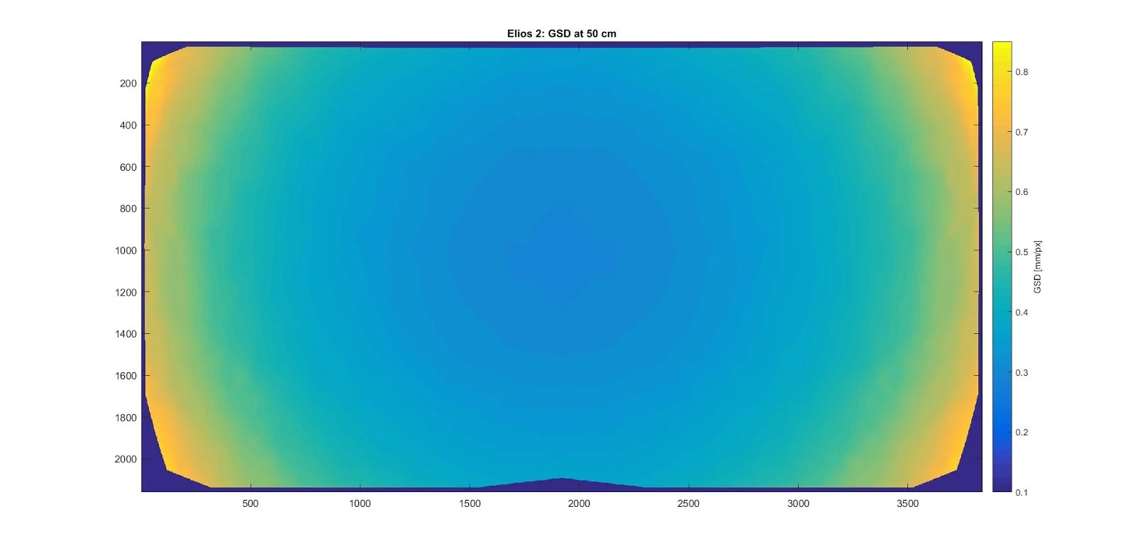
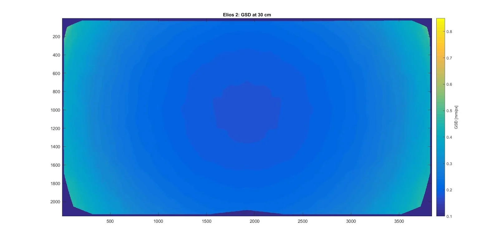
GSD variation across the image when the Elios 2 faces a vertical wall. Measured using a grid pattern.
GSD is essential for photogrammetry, but it doesn’t fully reflect image quality. Lighting, motion, and noise also affect what you can see in the final image.
Spatial Resolution
The **spatial resolution**, often measured in line pairs per millimeter (lp/mm), describes the smallest details that can be distinguished in an image. It accounts for blur, noise, and image processing—factors that influence how sharp the image appears. A spatial resolution of 2 lp/mm means two black-and-white line pairs can be clearly seen per millimeter. Higher frequencies will appear blurred or merged.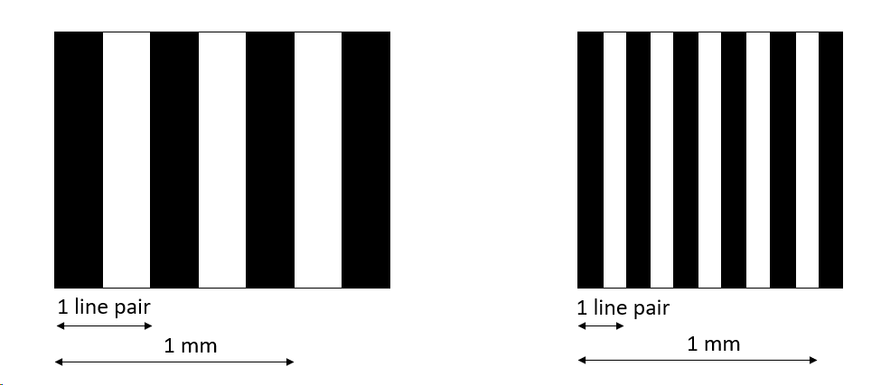
Left: 2.5 lp/mm. Right: 5 lp/mm
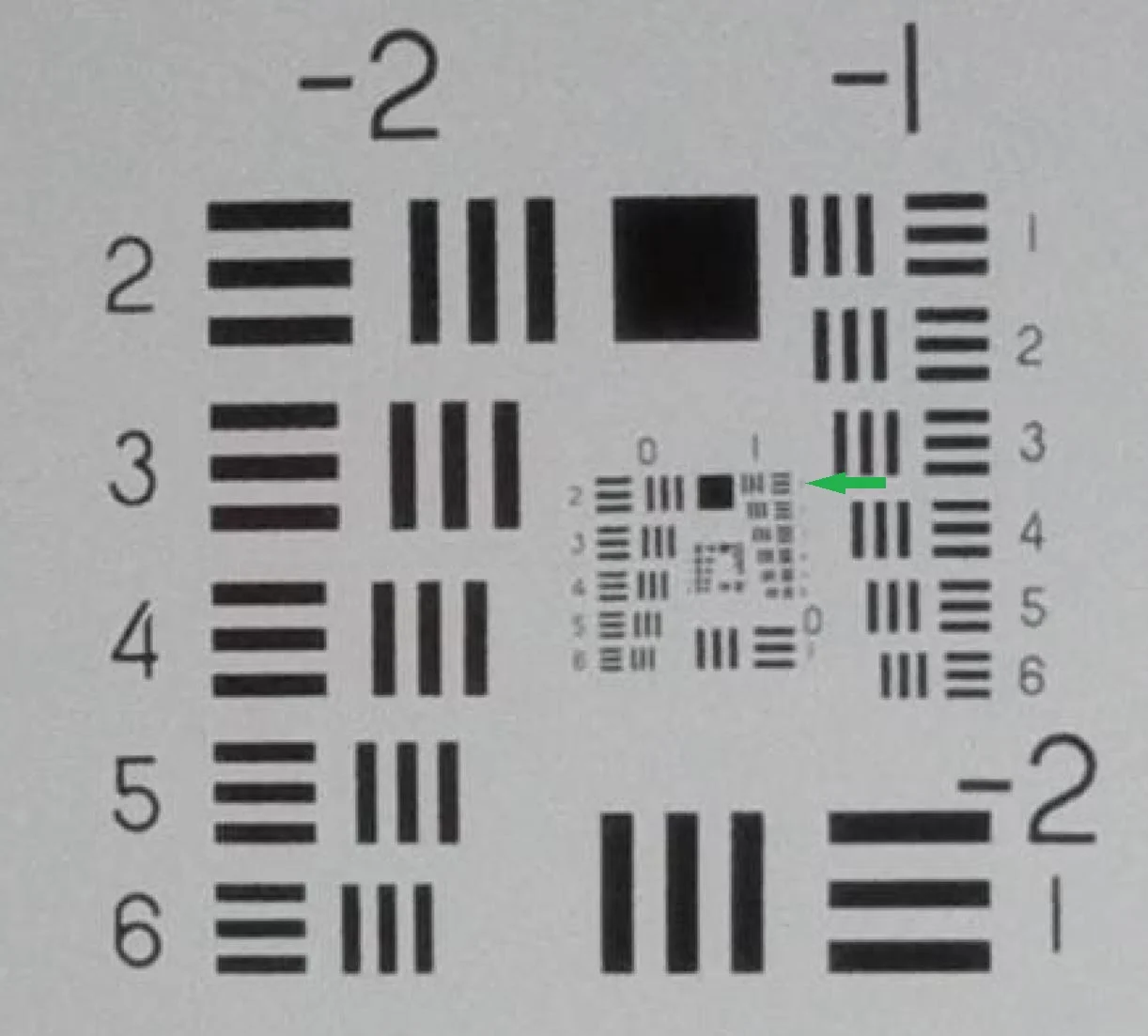
Smallest resolved element on a USAF 1951 chart by Elios 2 at 300 mm. Element 1 is clearly visible, while Element 2 starts to lose contrast.
Spatial resolution is highest in the center of the image and decreases toward the edges. It also depends on focus and depth of field. On the Elios 2, the best resolution occurs at 15–30 cm from the object. Too close, and the image becomes blurry.
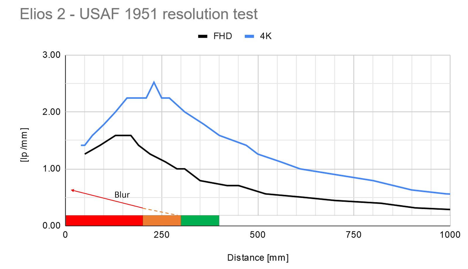
To ensure optimal spatial resolution, it's important to fly at the correct distance. The Elios 2 includes a distance lock feature and Cockpit software to show real-time GSD and spatial resolution via color codes:
| Distance | Color | Meaning | |
| > 40 cm | Â | White | Going closer increases spatial resolution |
| 30 to 40 cm | Â | Green | High spatial resolution and sharp image |
| 20 to 30 cm | Â | Orange | Highest resolution, but image may be blurry |
| < 20 cm | Â | Red | Image is very blurry. Spatial resolution drops. |
Keep in mind that small screens can make blur less noticeable. Even if the live feed looks sharp, your recorded footage might not be. Flying at 30 cm ensures the best balance between detail and clarity.
Other factors that improve image quality include:
- Good lighting to reduce ISO and exposure time
- A stable drone to avoid motion blur
- Clean lenses to prevent glare and blurriness
More Than Just Resolution
While spatial resolution is crucial, it's only part of the story. Other elements like lighting, color accuracy, and viewing angles also impact the quality of your inspection. The Elios 2’s compact design and collision tolerance allow it to get up close and capture detailed views from multiple angles. Its advanced lighting system helps highlight surface imperfections, making it easier to spot cracks, holes, and irregularities. With practice, you'll learn to optimize your flight path and focus on capturing high-quality data rather than just navigating. Understanding these resolution metrics will significantly enhance your results. Every industry has unique requirements for image quality. If you've tested different tools or have feedback about the Elios 2, feel free to share your experience with us!Other Material Bonding,Ultraviolet Light Glue,Uv Light Adhesive,Uv Adhesive For Glass
Guangdong Shengtang New Material & Technology Co.,Ltd. , https://www.shengtang-silicone.com