What is Simultaneous Localization and Mapping (SLAM)?
What is Simultaneous Localization and Mapping (SLAM)?
SLAM, or Simultaneous Localization and Mapping, is a powerful technology that enables robots and autonomous systems to build a map of an unknown environment while simultaneously determining their position within it. This dual process is essential for navigation in complex and dynamic settings where pre-existing maps are unavailable.
SLAM combines data from various sensors—like cameras, LiDAR, sonar, and more—with advanced algorithms to allow a robot or vehicle, such as a drone or self-driving car, to navigate through unfamiliar spaces. It's like having a robot that can both explore and remember where it has been, all at the same time.
This capability makes SLAM ideal for environments that are too dangerous, too small, or too complex for human exploration. From deep-sea surveys to space missions, SLAM is transforming how machines interact with the world around them.
Today, SLAM is used in everything from robotic vacuum cleaners to cutting-edge self-driving cars. As the cost of hardware and software continues to drop, we're seeing more and more practical applications of this technology across industries, including healthcare, logistics, and even entertainment.
What Is SLAM (Simultaneous Localization and Mapping)?
SLAM is a technique that allows a robot or autonomous system to create a map of its surroundings while also figuring out where it is within that space. The challenge lies in doing both tasks at the same time, which is why it’s often referred to as a "chicken or the egg" problem.
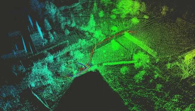
 Multi-robot SLAM experiment made during the DARPA Subterranean Challenge
While mapping and localization are typically separate processes, SLAM integrates them into one seamless operation. This approach has led to breakthroughs in robotics, enabling machines to operate independently in previously uncharted territories.
It's important to understand that SLAM isn’t a single product or system—it’s a concept that encompasses many different approaches and technologies. Depending on the application, developers can choose from a wide range of algorithms and sensor configurations to build a customized SLAM solution.
Most SLAM systems rely on two core components:
1. Range Measurement
These are the sensors that gather data about the environment. They can include LiDAR, cameras, ultrasonic sensors, and more. Each provides a unique way to measure distances, detect obstacles, and collect spatial information.
2. Data Extraction
This is the software layer that interprets the raw data from the sensors. It identifies landmarks, tracks movement, and builds a map in real-time. The complexity of this part varies depending on the system’s requirements and the type of environment it operates in.
Together, these elements form the backbone of any SLAM-based system, making it possible for robots and drones to move confidently and efficiently in unknown spaces.
How Does SLAM (Simultaneous Localization and Mapping) Work?
A SLAM-enabled device navigates by identifying and using landmarks in its surroundings. Think of it like a person exploring a new city: they look for recognizable features, track their movement, and gradually build a mental map of the area.
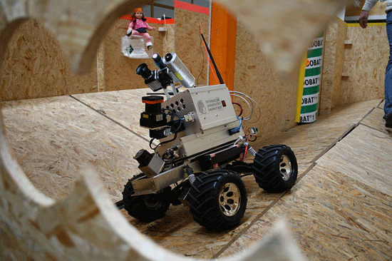 LiDAR-equipped robot | Credit: Technische Universität Darmstadt
SLAM works in much the same way. It detects key points in the environment, calculates the robot's position relative to those points, and uses this information to build a detailed map. The process is continuous and dynamic, allowing the system to adapt as it moves through the space.
This ability to map and localize in real-time is what makes SLAM so valuable. Whether it's a drone flying through a forest or a robot cleaning a home, SLAM ensures that the machine can operate autonomously and safely.
LiDAR and SLAM
LiDAR, short for Light Detection and Ranging, is a key component in many SLAM systems. It uses laser pulses to measure distances and create highly accurate 3D models of the environment.
LiDAR is especially useful in environments with limited visibility, such as dark or dusty areas. Its high precision makes it ideal for applications like warehouse automation, mining, and autonomous vehicles.
However, LiDAR isn't always the best choice. In open spaces with few obstacles, it can be harder for the system to align itself correctly. That’s why other technologies like sonar or visual SLAM are sometimes preferred, depending on the use case.
SLAM (Simultaneous Localization and Mapping) Applications
SLAM has evolved from a theoretical concept into a practical tool used in a variety of industries. As the cost of sensors and computing power decreases, more companies are finding innovative ways to apply SLAM in real-world scenarios.
Here are four exciting applications of SLAM today:
1. Cleaning Robots
One of the most common and familiar uses of SLAM is in robot vacuums. These devices use SLAM to navigate homes, avoiding obstacles and covering every corner without repeating the same path.
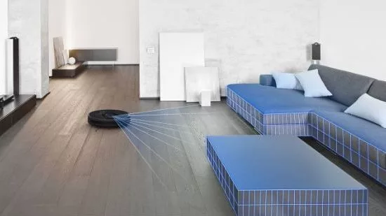
Without SLAM, a robot vacuum would simply wander aimlessly, bumping into furniture and failing to clean effectively. With SLAM, it can map the space, avoid obstacles, and work efficiently—making it a great example of how SLAM improves everyday life.
2. Entertainment
In 2021, The Walt Disney Company filed a patent for a Virtual World Simulator that uses SLAM to create immersive experiences in theme parks. This technology allows visitors to see digital elements overlaid on real-world environments, creating a fully interactive experience without the need for headsets or glasses.

This kind of innovation could revolutionize how people experience entertainment, blending the physical and digital worlds in new and exciting ways.
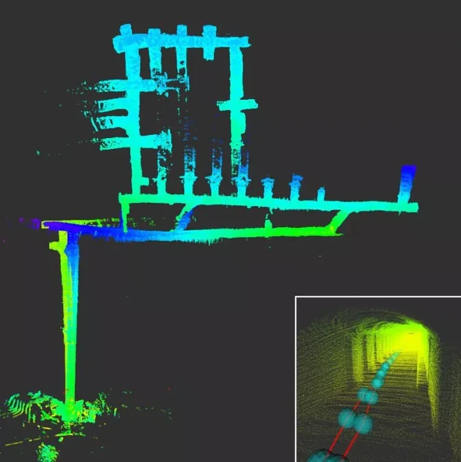
3. Medicine
SLAM is also being used in the medical field to improve surgical procedures. By creating real-time 3D maps of the body, surgeons can navigate internal structures with greater precision, reducing the need for invasive techniques.
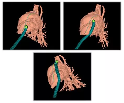 Credit: Howie Choset, Carnegie Mellon University
Medical SLAM helps doctors visualize complex anatomical structures, leading to safer and more effective surgeries. As the technology advances, it’s expected to play an even bigger role in minimally invasive procedures and robotic-assisted surgery.
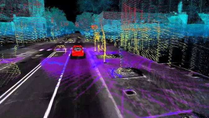
4. Self-Driving Cars
Self-driving cars rely heavily on SLAM to navigate roads, detect obstacles, and plan safe routes. Unlike GPS, which can be inaccurate in urban environments, SLAM provides real-time, high-precision location data.
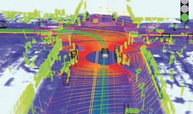 Credit: Science Direct
As SLAM technology becomes more advanced, self-driving cars will become even more reliable and capable of handling complex driving conditions. This is just one of the many ways SLAM is shaping the future of transportation.
SLAM Drones
Another exciting application of SLAM is in the field of drones. Autonomous drones equipped with SLAM can navigate through challenging environments, such as collapsed buildings, dense forests, or underwater sites, without human intervention.
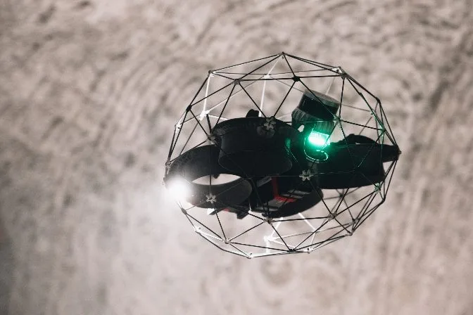 The Elios 3, a LiDAR-enabled drone created with SLAM capabilities
SLAM allows drones to map their surroundings, identify obstacles, and adjust their flight paths in real-time. This makes them ideal for search and rescue operations, infrastructure inspections, and environmental monitoring.
Although some high-speed drones may not be compatible with all SLAM systems, slower, more precise models can use SLAM to create detailed 3D maps of hard-to-reach locations. Whether it's inspecting a bridge or surveying a disaster site, SLAM-enhanced drones are opening up new possibilities in aerial technology.
Ultimately, SLAM is more than just a technical term—it's a transformative force that is changing how machines perceive and interact with the world. As the technology continues to evolve, we can expect to see even more creative and impactful applications in the years to come.
[Related read: Elios 3's Indoor 3D Mapping Helps City of Lausanne in Water Department Inspections]
Ceramic Scraping Plate,Custom Ceramic Scraping Board,Customized Steatite Ceramic,Steatite Ceramic Scraping Board
Yixing Xiangyang Jiujiu Chinaware Industry Co., Ltd. , https://www.xyjjceramic.com