What is Simultaneous Localization and Mapping (SLAM)?
What is Simultaneous Localization and Mapping (SLAM)?
SLAM, or Simultaneous Localization and Mapping, is a powerful technology that enables robots, drones, and autonomous vehicles to create a map of an unknown environment while simultaneously determining their own position within it. This dual process is essential for navigation in environments where pre-existing maps are unavailable.
SLAM systems use a combination of sensors, algorithms, and computational power to allow autonomous devices to explore new spaces. Whether it's a robot vacuum navigating your home or a self-driving car on the road, SLAM plays a crucial role in helping these machines understand and interact with their surroundings.
This technology has opened up new possibilities for exploring areas that are too dangerous or inaccessible for humans. From deep-sea exploration to disaster response, SLAM helps machines operate in complex and dynamic environments.
As the cost of hardware and software continues to drop, SLAM is becoming more accessible and is finding its way into a wide range of applications, from consumer electronics to industrial automation and beyond.
What Is SLAM (Simultaneous Localization and Mapping)?
At its core, SLAM is the process by which a robot or autonomous system builds a map of an unfamiliar space while also figuring out where it is within that space. It’s like a real-time puzzle where the device must constantly update both the map and its location as it moves.
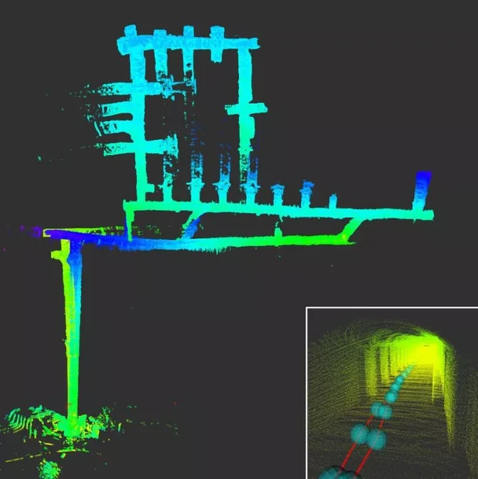 Multi-robot SLAM experiment made during the DARPA Subterranean Challenge
Historically, building a map and knowing your location were seen as two separate problems. But SLAM solves them at the same time, making it one of the most important technologies in robotics and autonomous systems.
It’s not a single product or system but rather a concept that can be implemented in various ways depending on the application. Different types of sensors, such as LiDAR, cameras, and sonar, can be used to gather data, and specialized software processes that data to build a map and track the device's position.
Most SLAM systems consist of two main components: range measurement and data extraction. These work together to provide accurate and real-time information about the environment and the device's position within it.
How Does SLAM (Simultaneous Localization and Mapping) Work?
SLAM works by identifying landmarks and using them to determine the device’s location and build a map of the environment. This process is similar to how a human might navigate through an unfamiliar area.
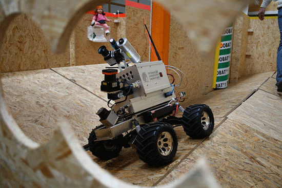 LiDAR-equipped robot | Credit: Technische Universität Darmstadt
Imagine you're in a new city without a map. You look around for recognizable landmarks, estimate your distance from them, and use that information to orient yourself. As you move, you continue to identify new landmarks and refine your understanding of the space.
SLAM does something very similar. It detects features in the environment, calculates its position relative to those features, and updates the map in real time. This allows the device to navigate efficiently and safely, even in unstructured or changing environments.
LiDAR and SLAM
LiDAR, short for Light Detection and Ranging, is a key sensor used in many SLAM systems. It uses laser light to measure distances and create detailed 3D maps of the environment.
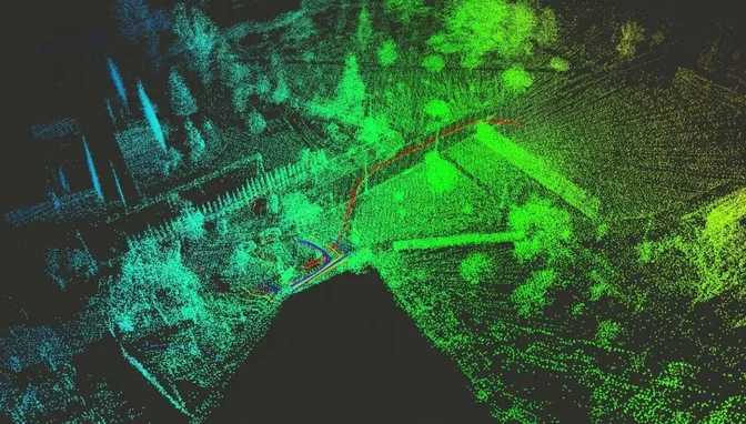
LiDAR is particularly useful in environments where visibility is limited, as it doesn't rely on ambient light. It's widely used in applications like warehouse automation, mining, and autonomous vehicles.
However, LiDAR isn’t always the best choice. In open spaces with few obstacles, it may struggle to align with point clouds, leading to inaccuracies. In such cases, other sensors like cameras or sonar may offer better performance, depending on the specific use case.
SLAM (Simultaneous Localization and Mapping) Applications
SLAM is no longer just a theoretical concept—it’s being used in real-world applications across multiple industries. As the technology evolves and becomes more affordable, its impact is growing rapidly.
Here are four exciting areas where SLAM is making a difference:
1. Cleaning Robots
One of the most common examples of SLAM in everyday life is the robotic vacuum cleaner. Without SLAM, these devices would just wander randomly, bumping into furniture and failing to clean effectively.
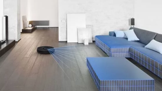
With SLAM, these robots can map the layout of a room, avoid obstacles, and remember which areas have already been cleaned. This makes them much more efficient and user-friendly.
2. Entertainment
SLAM is also transforming the entertainment industry. For example, Disney recently filed a patent for a “Virtual World Simulator†that uses SLAM to create immersive 3D experiences in real-world settings.

This technology could revolutionize theme parks by allowing visitors to experience interactive virtual worlds without the need for headsets or glasses. The potential for future applications is enormous.
3. Medicine
In the medical field, SLAM is helping doctors perform more precise and minimally invasive surgeries. By creating 3D models of internal organs, surgeons can navigate with greater accuracy and reduce the risk of complications.
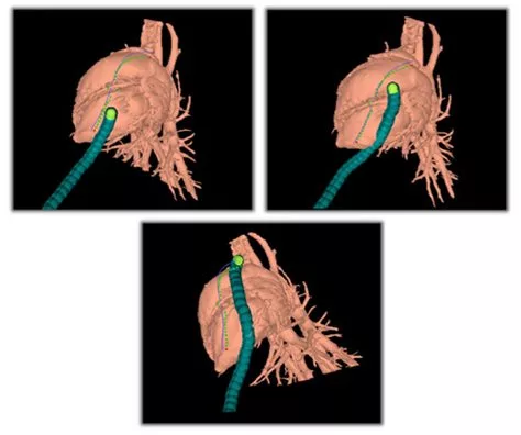 Credit: Howie Choset, Carnegie Mellon University
This application of SLAM is especially valuable in procedures where traditional imaging methods fall short, such as in laparoscopic surgery or endoscopic examinations.
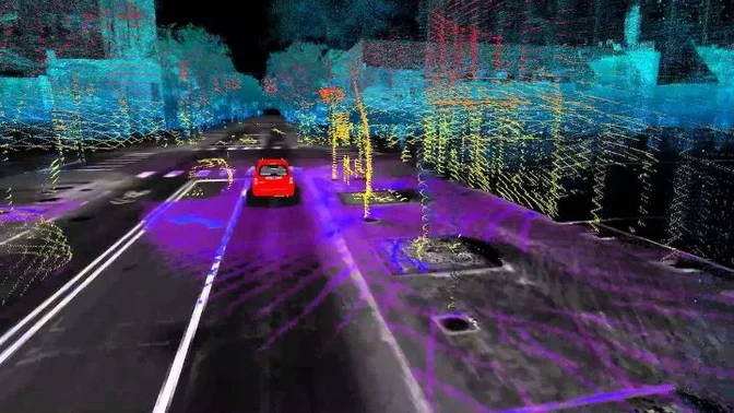
4. Self-Driving Cars
Self-driving cars rely heavily on SLAM to navigate roads, detect obstacles, and make real-time decisions. Unlike GPS, which can be inaccurate in urban environments, SLAM provides a more reliable and detailed understanding of the vehicle's surroundings.
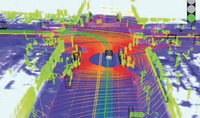 Credit: Science Direct
As SLAM technology improves, we can expect to see even more advanced autonomous vehicles that are safer, more efficient, and capable of handling complex driving scenarios.
SLAM Drones
Another exciting application of SLAM is in drone technology. Autonomous drones equipped with SLAM can map large areas, avoid obstacles, and navigate complex environments—making them ideal for tasks like inspection, search and rescue, and environmental monitoring.
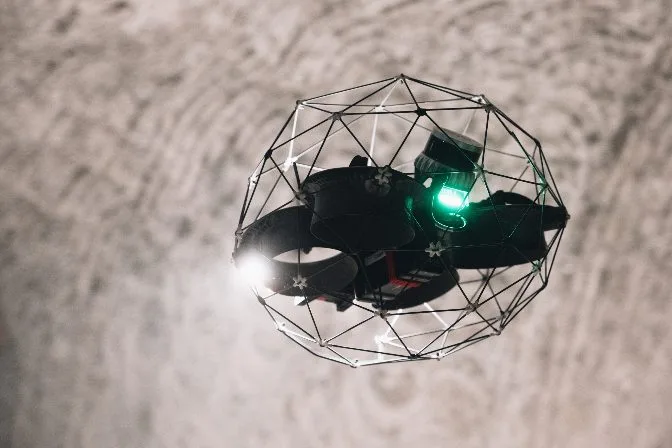 The Elios 3, a LiDAR-enabled drone created with SLAM capabilities
SLAM allows drones to operate in real-time, adjusting their flight paths based on the environment. This is especially useful in situations where manual control is impractical or unsafe, such as in confined spaces or hazardous locations.
While some high-speed drones may challenge the accuracy of SLAM systems, slower-moving drones can benefit greatly from this technology. They can create detailed 3D maps of hard-to-reach areas, from underwater sites to dense forests, providing valuable data for research, safety, and planning.
Ultimately, SLAM is a versatile and evolving technology that is shaping the future of robotics, automation, and exploration. Whether it's in our homes, hospitals, or on the roads, SLAM is helping machines become smarter, safer, and more capable than ever before.
Artware Ceramic Products,Steatite Artware Ceramic Parts,Cordierite Ceramic Spoon,High Frequency Ceramic Earpick
Yixing Xiangyang Jiujiu Chinaware Industry Co., Ltd. , https://www.xyjjceramic.com